


June 15, 2014 – Welcome to
Canada
Whitehorse, Yukon
Day 152 - Distance biked
so far: (10,076 km)
I boarded the
plane in Sydney and settled into the 14-hour flight to Los Angeles and then
another few hours to Vancouver. Since I crossed the International dateline, I
left Australia on May 30th and arrived in Canada on the same day, don’t
ask me to explain how that works.
My cousin Gary
met me at the airport. Our family is a little unique in that in my parent’s
generation, 3 brothers married 3 sisters and my parents and Gary’s parents are
one of those sets. That means my father and Gary’s father are brothers, and my
mother and Gary’s mother are sisters. Gary lives with his wife Sue just outside
of Vancouver and I was staying with them for 3 nights. I had ordered a new set
of pannier bags for my bike as the old ones were hanging on by a thread and I
had them delivered to Gary and Sue’s house. Here is my new bike set up with the
same flag of the Philippines that has been with me every step of the way.
 |
| New pannier bags |
On Saturday we
all went shopping. In addition to the bike bags that I ordered online, I had to
buy a number of things for my trip to the north. The first item on my list was
a new sleeping bag. My old one was only suitable for summer and I knew that I
could get some cold nights in the Arctic or some of the high mountain passes in
the Rocky and Andes Mountains later on. I spent a lot of cold nights in the
southern part of Australia and new my bag would not be up to the task here. The
other significant purchase was a water filter. In the Outback of Australia, I
had to carry water bottles, as there was little in the way of water to filter.
In the North, they generally have ample fresh water but there is still a risk
of contracting bacteria since animals use that water. To avoid that problem you
simply filter it before drinking so instead of large cumbersome bottles, you
just carry a filter and fill your water bottles directly from the river. It
saves a lot of weight and money. Here is a photo of how it works. One end is a
filter and it lies on the water. A pump handle with another filter is used to
fill the water bottles. I always place the filter in moving water; it only
takes a few seconds to fill the bottles.
 |
| Water filter |
After shopping
we walked around the waterfront area of Vancouver. I have travelled to a lot of
cities in the last few years but I still think Vancouver is the most beautiful
city in the world. It is hard to beat having an ocean on one side and mountains
that often have snow on top on the other. It is a manageable size and not
nearly as cold as most of Canada. They can often go years without any snow and
if it falls it rarely lasts more than a day or two.
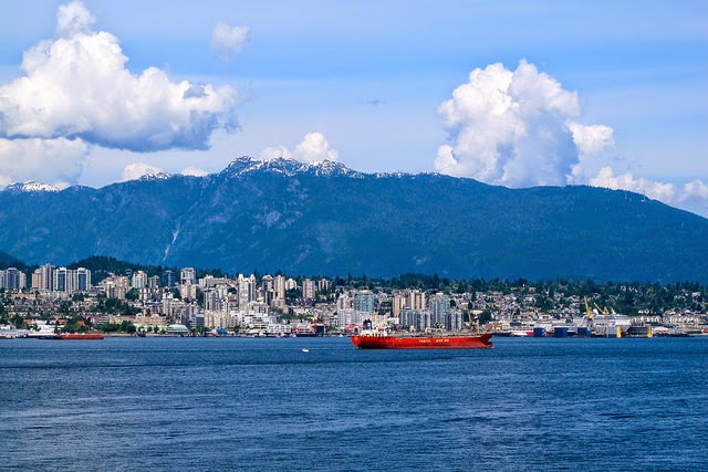 |
| North Vancouver Mountains |
Vancouver/Whistler
hosted the 2012 Winter Olympics and we were down by the Olympic flame.
 |
| Olympic Park |
 |
| Gary and Sue |
On Monday June
2nd, I reluctantly pulled myself out of a very comfortable bed and
Gary drove me to the airport. Once again I had to say good-bye, a recurring
theme of travelling. Gary and Sue have a beautiful home and with Sue’s
fantastic vegetarian cooking and some excellent coffee, it was really hard to
leave. They could not have been better hosts and the 3 days flew by way too
quickly.
It is not a straightforward
effort to get to the far north. I took the 2-hour flight from Vancouver to
Whitehorse and then spent a night at a youth hostel. I will be cycling back
down to the same spot so will write more about the City later. The next morning
was another flight of about 1.5 hours to Old Crow and then a final 1-hour hop to
Inuvik. Just 6 days earlier I was in Sydney, Australia and now above the Arctic
Circle in the Northwest Territories of Canada. Jet travel has made it a small
world but it seems a lot bigger when you travel on a bicycle.
Canada is a
massive country, the second largest in the world. It borders 3 oceans, the
Pacific in the west, the Atlantic in the east and the Arctic in the north with
the southern boundary shared with the U.S. There are 10 Provinces and 3 Territories
and Inuvik is in the Northwest Territories. It is located on the Mackenzie
River and it is so far north that you have to drive 200 km south to get to the
Arctic Circle. It is only 100 km from the Arctic Ocean.
Inuvik enjoys
56 days of 24-hours a day of sunlight each year, starting in late June until
the early part of August. That is the good news and the bad is that they also
have 30 days without any sunlight in the winter. It was odd trying to adjust to
the daylight. On the day I arrived I had to put my bike together, pack my
pannier bags and set up my tent and was completely oblivious to the time
because it was daylight. I checked my watch at one point and it was 9:30 pm and
as light as it would be at noon. I got up on my first night and took this photo
at exactly midnight.
 |
| Inuvik at midnight |
On the day I
arrived in Inuvik, I found it very cold. It was only 4 degrees in mid-afternoon
and it had gone down to minus 8 degrees that morning, significantly cooler than
normal and a good reminder of why I made the decision to get a warmer sleeping
bag. I heard it was going to warm up however, and the forecast looks like
sunshine with low temperatures of about 0 degrees and highs of 10 degrees. The
record temperature in Inuvik is 32 degrees, which is quite hot. It’s not the
same as a 32-degree day in Bangkok or Manila because the air is very dry here
but it does get warm. The record low here is minus 57 degrees but that is in
mid-winter. I can’t imagine a day in December without sunlight and temperatures
of minus 50 degrees. Now you know why there are so few people here.
A distinct
feature of Inuvik is the use of Utilidors, above ground utility conduits
carrying water and sewer, which are covered by corrugated steel. They run
throughout the town connecting most buildings. They are necessary because of
the permafrost. When permafrost, or permanently frozen ground thaws during the
warm summer months, the ground shifts and building materials lose their
support. Most of the buildings in Inuvik sit above ground on pilings drilled
into the permafrost below. In between the ground and the floor of the building
is an open crawl space to ventilate building heat away from the ground to
prevent the permafrost from melting.
 |
| Water pipes in Inuvik |
The Our Lady
of Victory Church is a major landmark of Inuvik. It ‘s called the Igloo church
and the name comes from the shape, it is not made of snow.
 |
| Igloo Church |
Here’s a handy
way to transport kids in Inuvik.
 |
| Children train in Inuvik |
With the
presence of bears, all the garbage containers have to be bear proof. Here is an
example of all the garbage containers up here and throughout bear country. They
are designed to prevent the bears from finding food which would make them
return to the populated areas.
 |
| Bear proof garbage cans |
The Dempster
Highway was completed in 1979 and is the only highway in Canada that crosses
the Arctic Circle. The highway is open year-round except for short periods
during the spring thaw and fall freeze, as you have to take a ferry at 2
different locations. It is a 2-lane gravel-surfaced all-weather highway. It is
unique in highway design and construction. It sits on top of a gravel berm to
insulate the permafrost in the soil underneath. The thickness of the gravel pad
ranges from 1.2 meters up to 2.4 meters. Imagine the amount of gravel it would
take to create a 2-meter high surface for 760 km. Without the pad, the
permafrost would melt and the road would sink into the ground. I would be
cycling on sections of hard-packed dirt, loose gravel and sharp shale, so there
is a high risk of flat tires. The materials used on the road vary depending on
what type of material can be found nearby. As they were building, they created
small side roads that would lead to the rivers and then get a large machine to
dig up the rocks. Sometimes the rocks on the road were smooth and round and other
times they were sharp. I purchased 2 new tires prior to leaving Sydney and
picked up a spare before landing in Inuvik.
My main
concern however was not getting flat tires; it was facing one of my fears,
biking through bear country. I have this unrealistic fear of anything that can
eat me. It was the saltwater crocodiles in Australia and now that I survived
there (without actually seeing one in the wild but that is beside the point) it
is now time to face the bears of North America. I know it is rare but attacks
do occur. I looked up the statistics of course and confirmed that since 1970,
there have been 50 people killed by grizzly bears, 46 killed by black bears and
8 killed by polar bears. Polar bear attacks are rare because they typically
live where there are no people. That is the good news. The bad news for me
however is that the Dempster Highway has a lot of grizzly and black bears. When
it comes to bears I realize that I am falling into the same trap as people
(like me) who have a fear of flying. We have a fear out of proportion to the
risks, mainly because of the sensational reporting. I read an interesting
series of statistics that attempted to put everything into perspective. For
each person killed by a black bear, there are 13 killed by snakes, 17 by
spiders, 45 by dogs, 120 by bees, 150 by tornadoes, 374 by lightning and 60,000
by humans. Maybe my fear is because out of all those, only bears would eat me. The
perspective was lost on me however; I refuse to let facts get in the way of the
impending bear attack.
My first
question for the locals when I arrived in Inuvik was if they ever had polar
bears in the area. Polar bears are really something to fear; once they start
tracking you there is little escape, especially if you are on a bike. I was
told that Polar bear territory does not extend down to Inuvik but stops about
160 km up the road in the town of Tuktoyuktuk, known simply as Tuk. Tuk is only
accessible by an ice bridge in the winter and the only way to get there in the
summer is by plane. However, polar bears are incredible swimmers so that was
the reason for my question about spotting them down in Inuvik. I found out
later that in 2007, a polar bear was indeed spotted on the Dempster Highway;
you can find the story online. It was darted and relocated with a radio
transmitter to track his movements. They attribute his roaming to global
warming and a loss of hunting grounds. I am just glad I didn’t read about that
polar bear until after I finished cycling down. Along the Dempster Highway
there are moose, bears, wolves, wolverines, lynx, caribou and elk, it felt at
times that I was cycling through a zoo without a fence.
You can’t
completely protect yourself but I had to do the best I could so had a few
routines that I went through consistently. First, I carried bear spray. Here is
the can in my front handlebar bag. I tested it out and it shoots a powerful
orange spray but it really would be a last resort against a charging bear.
 |
| Bear spray |
The biggest
risk is when you cook food as bears have a great sense of smell, better than
dogs. A polar bear can smell a seal from a kilometer away. I would not be
eating anything with a strong smell like canned fish. My diet would consist
strictly of oatmeal, nuts, pasta and tomato sauce. I also did not sleep near
where I ate. I would set up my stove to cook a meal and then bike away from
that place to set up my tent. I would also take off any clothes that I was
wearing when cooking and change into different clothes to sleep.
My closest
encounter with bears was on my 4th day on the highway. I was cycling
through an area I had been warned was full of bears. Most nights I would stay
at a campground, which is probably more dangerous because a lot of tourists
want a photo of a bear, so leave food out to attract them. A bear then
associates a human with food so they hang around waiting for dinner. The area I
was in passes through the Richardson Mountains and is a popular spot for
caribou. If there are caribou around, you can guarantee the grizzly bears are
close and it’s best to keep moving. I had been told not to camp in that area
but it was 175 km between campgrounds and on gravel and hilly roads, I had no
choice. I was biking near the end of my day and saw a black bear running across
the road. They are normally scared of people but I wasn’t about to set up a
tent with him around. I continued biking debating how far a bear can walk in a
night before looking for another place to set up my tent. The area was wide
open and someone told me that is good because you can see a bear a long way off.
I replied that it also means a bear can see me. After about an hour of biking I
started to get tired so was looking for a suitable place to sleep. Just as I
started thinking I was far enough from the black bear I saw a grizzly bear in
the distance. They have a distinctive shape and although it paid no attention
to me, it was enough to keep me on my bike. They are majestic animals but I
would appreciate them more if I was on the other side of a fence, a very high,
strong fence. I kept moving forward and ended up biking almost 12 hours that
day. I didn’t mean to bike that far but it’s amazing what fear can do in terms
of endurance. I ended up finding a cleared out area with a few piles of gravel
and set up my tent. I didn’t eat anything and just fell asleep, a very
tentative sleep to say the least.
It turned out
that those were the only bears I saw on the entire stretch of highway. I did
see a large variety of wildlife and didn’t get a picture of any of them. If I
stopped to get my camera out they would be long gone. I saw lots of rabbits;
they would come right on the road and watch me until I got close and then run
away. I also saw a fox and a few caribou in the distance but for the most part
it was the incredible scenery that held my interest.
The northern
section of the highway was relatively easy to cycle with hard packed gravel. On
June 4th I headed off and the temperature when I left at about 9:00
am was a crisp 6 Celsius but the sun was shining and with it the promise of a
warm day. The temperature ended up peaking at about 16 Celsius and it felt warm
in the strong sun, a perfect day to bike above the Arctic Circle. Here are a
few pictures as I set off south along the Dempster Highway south of Inuvik.
 |
| Gravel road |
 |
| View heading south on the Dempster |
There are 2
ferry crossings you have to take along the highway. In the winter, the vehicles
drive across the frozen rivers and in the summers they have ferries. There are
short periods in the spring and fall when it’s not possible to get through. The
rivers only opened a few days before I started from Inuvik so my timing was
perfect. I could still see the ice on some of the rivers.
 |
| Thawing |
 |
| Ice on the river |
About a month
ago, a celebrity from Canada cycled down the highway. Clara Hughes is the only
person in history, male or female, to have won multiple medals at both the Summer
and Winter Olympics. She was a medalist in cycling and speed skating, one of
the greatest accomplishments in Olympic history. She is cycling across Canada
and raising funds for a charity, one of the many reasons why I have such
admiration for her. She could rest on her Olympic success but continues to use
her incredible athletic talents to support worthwhile causes. She was in Inuvik
about a month before me and cycled with a support team. She arrived at the
rivers and could not cross because the ice was melting so biking across was out
of the question and the ferries could not operate. So what do you do when an
Olympic hero is trying to get across 2 rivers in the Yukon? Simple, you call in
a helicopter to carry her over the rivers.
The first
river to cross was the Mackenzie. I boarded the ferry for the short ride to the
very small community of Tsiigehtchic, pronounced exactly as it’s spelt. It used
to be known as Arctic Red River but the name was changed in 1994. After the
land claim settlements many of the villages in the area reverted to their First
Nations name. The town is at the confluence of the Mackenzie and Arctic Red
Rivers and offers a panoramic view of both.
 |
| View of the Mackenzie River |
They do not
have a campsite and only one general store but I ended up setting up a tent
behind the old church on top of the hill.
 |
| Church in Tsiigehtchic |
I arrived late
to the town and set up. I have been disoriented in terms of the time of day
since it never gets dark. I had no idea how late it was but when I settled into
my tent it was already 10:00 pm. I saw another tent but didn’t disturb those
inside. In the morning, I was up to cook my breakfast of oatmeal, walnuts and
raisins when a girl emerged from the tent. She is Canadian and on a long hiking
trip with her boyfriend. They are hiking the length of the Trans Canada hiking
trail. They plan on spending the next 15 months hiking the 7,500 km from Inuvik
to Saint John’s Newfoundland. The Trans Canada Trail is the world’s longest
network of recreational trails. It is not fully completed yet but when done, it
will stretch 23,000 km from the Atlantic to the Pacific and the Arctic Oceans.
As of 2012, the trail was 73% complete but they will bridge the remaining sections
on their own. The Dempster Highway is the Trail that goes up to Inuvik so they
will be walking on the same road I bike until they get down to Dawson City,
where the trail branches off the highway.
I crossed the
second river crossing the next day. Just past the town of Fort McPherson you
have to cross the Peel River to continue south. I boarded the ferry and they
waited for a few vehicles so the crew invited me up to the captain’s deck to
get out of the cold wind. I met a man who lived in Tuk and he enthralled me
with some stories of life in the Arctic. I ended up staying on the ferry for
over an hour, crossing the river a few times before heading off. Here is the
captain.
 |
| Ferry Captain |
The captain
told me that in late July he would be taking a week off to go whale hunting. In
Tuk, they hold an annual lottery to allow 3 teams of hunters to hunt Beluga
whales. The town has a quota of 3 whales and the meat is shared with the entire
community. Only certain native people are allowed to hunt Beluga whales, as
they are a protected species. He told me that they take out a small 5-meter boat
with an outboard motor, incredibly small when you are hunting a whale. One of
the hunters will carry a harpoon and when they guide the small boat to the side
of the whale, they throw the harpoon. Once the harpoon is embedded in the
whale, they shoot it near the blowhole to kill it. You have to harpoon it first
because if you shoot it before the harpoon, you will kill the whale and it will
sink into the ocean. Once the whale is dragged to shore, the whole community
gets involved in cutting it up. The whale meat and blubber is called Muktuk and
it is carved up and placed in large pails. It is sometimes eaten raw but
usually boiled before eating. The captain told me that the entire whale is used
and nothing goes to waste.
Most of the day
biking on the highway provided panoramic views.
 |
| Wide-open spaces |
 |
| Blue lake beside the Dempster Hwy. |
The Arctic
Circle is the southernmost latitude in the Northern Hemisphere at which the sun
can remain continuously above (in the summer) or below (in the winter) the
horizon for 24 hours. Since Inuvik is about 200 km above the Arctic Circle, as
soon as I crossed the line I would be heading down to where I would see some
darkness at night.
 |
| Arctic Circle |
One day I rode
a long stretch in the cold and rain and it was completely fogged in. It was a
very difficult day and the area I went through was reportedly full of bears. I
would be riding down empty roads with the thick fog creating an eerie silence. Here
is a view of the fog just starting to roll in.
 |
| Storm clouds |
 |
| Fog moving in |
 |
| Greenery along the Dempster |
 |
| View of Ogilvie Mountains |
The landscape
became more mountainous as I headed into the Ogilvie Mountain range and then
the Tombstone Territorial Park. The scenery made it hard to bike without
stopping to take in the views.
 |
| Mountains and valleys |
 |
| Mountains on the Dempster |
 |
| Tombstone Mountain |
The gravel
road on the Dempster was hard to cycle and something I really don’t enjoy. It
slows you down but the real problem is that you have to look down to watch
where you are going so can’t enjoy the scenery. One day I went down a steep
hill and despite pulling on my brakes was going 40 kmh when I hit a long
stretch of thick gravel. My bike fishtailed a few times and I took my shoes out
of the clips to prepare for a fall. I didn’t want to be locked in because of
the risk of breaking an ankle so prepared to wipe out and braced myself but
managed to keep the bike steady. You get a feeling of being ripped off when you
struggle slowly up hills and don’t get the benefit of a fast downhill. Despite
the slow average speed, with the long daylight hours and my reluctance to just
sit in a tent and try to sleep in the daylight, I was making reasonable
progress. On my 7th day I arrived at the end of the highway and the
start of asphalt.
 |
| The end of the Dempster Highway |
The Dempster
Highway ends at the Klondike Highway and I turned west for the 40 km stretch to
Dawson City. If you ask most people where the western most point of Canada is,
many will say the British Columbia cities of Vancouver or Victoria but you have
to look to the Yukon, not British Columbia. The most Western city in Canada is
Beaver Creek on the Yukon/Alaska border and not far from Dawson City. It will
be my most western point in North America.
 |
| Welcome to Dawson City |
There was no
red carpet rolled out but I did appreciate the double rainbow to mark my
arrival.
 |
| Dawson City under a rainbow |
Dawson City
was the original capital city of the Yukon until it was displaced after the
building of the Alaska Highway that bypassed the town and increased the profile
of Whitehorse, the current capital. Dawson City came to prominence in 1896 when
gold was discovered nearby and it quickly became an overnight boomtown.
Thousands of recession-stricken adventurers were lured north starting the gold
rush of ’98. For a brief period at the end of the 19th century,
Dawson City had a population of over 30,000 and was the largest Canadian
settlement west of Winnipeg. Today, there are about 2,000 year round residents,
with tourism making the largest contribution to the economy. The City is
designated as a National Historic Site and its appearance is largely unchanged
due to the dedication in preserving historic sites. It is described as a living
museum with boardwalk-lined streets and historic buildings.
 |
| Dawson City storefronts |
Staff at Parks
Canada have staff dressed in the dress of the day and give regular walks and
tours to the tourists. I joined a free walking tour of some of the old
buildings. Here is an old saloon that has been preserved to its original
likeness.
 |
| An old saloon |
The City is
set on the edge of the Yukon River and surrounded by green hills making it a
spectacular location. I found a campsite right along the Yukon River. I arrived
late in the evening and you can pick your own site. I stopped my bike and was starting
to unpack when a guy across from me approached. He said that he does a lot of
meditation and my presence was interfering with his energy so asked me to
leave. I did leave, not to ensure he had the right energy, but to get away from
him. Here is my campsite on the Yukon River in Dawson City.
 |
| Camping on the Yukon |
I left the
City on a sunny and warm day with temperatures close to 20 Celsius. I would be
riding in shorts and a t-shirt for most of the day, not really what you would
expect for being so far north. The nights have been about 5 degrees so no
problem in my warm sleeping bag. It is odd but I had much colder nights in the
south of Australia where it was late fall than I have had above the Arctic
Circle in early summer.
I continued on
the Klondike Highway that joins Dawson City with Whitehorse. There are a series
of very small towns dotting the road but it would be an entire day of cycling
between them, with no services of any kind. I would stay at campsites, many
were free and in locations near the towns so you could buy some supplies. The
scenery was beautiful and in this photo I had a hard time counting how many
different shades of green.
 |
| Shades of green |
You could
often see snow packed mountains in the distance.
 |
| View near Moose Creek |
There would
also be numerous rivers and lakes on the route.
 |
| Stewart River |
And finally I
would see roads with flowers that seemed to line the route for miles.
 |
| Flowers lining the Klondike Hwy. |
On a few
occasions I would bike down the road and hear a loud scramble and see a large
black rear end heading for the trees. Most of the time bears will run when they
see a human being. In addition to my bear spray, I carry 2 pot lids in my front
handlebar bag. Bears often graze on the side of the roads and have become accustomed
to the cars passing. If I see bears ahead I will bang the lids to warn them of
my approach. One day I came across a female Moose that was crossing the road. I
stopped to take a photo and watched her slowly cross. She heard a car approach and
then simply walked off into the bush.
 |
| Moose |
For most of
the time I had warm and sunny days with steady but not strong head winds the
entire way. The roads are hilly but with reasonable grades so not difficult.
Here are some more photos of the scenery as I approached Whitehorse.
 |
| View near Pelly Crossing |
 |
| View near Carmacks |
I had a guest
for lunch at one rest stop.
 |
| Company for lunch |
One night I
stopped to camp on the side of the road and a local groundhog kept reminding me
that he lived here and I was not welcome. I told him to go sleep in his home
and I will sleep in mine but he didn’t listen and spent a few hours making
calls at me to leave.
 |
| My groundhog friend |
I passed the
10,000 km mark on the Klondike Highway approaching Whitehorse.
 |
| 10,000 km |
As I neared Whitehorse,
I made a slight detour to go to Muktuk Adventures, something I was looking
forward to since I left Inuvik. I had contacted them and made arrangements to
stay there in my tent for 2 nights. As mentioned earlier, Muktuk is a term that
means whale blubber but it is also a ranch started in 1995 by Frank Turner and
his wife Anne. Frank is a Yukon Quest legend who competed in the race 24 times,
crossed the finish line 17 times and won the race once, in a time that stood as
the record for 12 years. The Yukon Quest is a 1,600 km International Sled Dog
Race run every February between Fairbanks, Alaska and Whitehorse, Yukon.
Because of the harsh conditions, difficult trail, and the limited support that
competitors are allowed, it is considered the most difficult sled dog race in
the world and often, the toughest race in the world. It has been referred to as
the wintertime Tour de France.
I was very
excited to be there to see the 124 dogs on the property. I was told that I
could spend a day with the dogs and I was anxious to meet them. As I biked
closer, I could hear some dog barking in the distance so new I was on the right
road. I saw a few signs that made me chuckle.
 |
| A new definition of happiness |
 |
| My kind of place |
This was my
first view of the dogs.
 |
| The pack of dogs |
The dogs were
beautiful and very friendly. This is Blue, the most energetic of the entire
group. He was always on the lookout for evidence of food and at 8 in the
morning and 5 in the afternoon; he would sit on his house with his eyes fixated
on the pails of food. Once the volunteer workers would pick up the pails and
move toward the dogs, he would run in circles, up and over his doghouse
numerous times. I think he burned more calories waiting for his food than he
ate at his meals.
 |
| Blue on the watch |
He was so
energetic that he tried to dig his own river.
 |
| Blue’s moat |
Here is a
close up of his eyes.
 |
| Alaskan Husky |
The dogs are
not pure breeds and have different mixtures. They are surprisingly small but
extremely fit and strong. They have been bred with the best genes to create a
dog that can run for 100 miles at a time. They are like the lean marathon
runners, deceptively fast and strong. This dog definitely had some wolf in him.
 |
| Looks like a wolf |
My favourite
dog was Emma. She was very shy and I had trouble petting her so sat on the
ground near her house for almost an hour and slowly she approached. By the end
of the day, we were good friends.
 |
| Emma |
I camped on
the grounds and ate meals in the Lodge. Frank would be there and tell us
stories about the dogs and the races and I was enthralled. Here is my campsite
along the river.
 |
| Camping by the Yukon |
This was the view
from the front of my tent.
 |
| My campsite at Muktuk Adventures |
A storm was
approaching on the first night and it looked like it was getting dark but the
storm passed with only a light rain.
 |
| Rain clouds |
Frank did
tours of his property and they took the dogs for vigorous runs every day. In
the winter, Muktuk Adventures holds tours where you can follow behind the Yukon
Quest race. It involves camping outside in the winter where it often goes down
to minus 40 degrees and you can have the chance to drive a dog sled. It would
be a thrill to join that tour. I loved it there and was treated very well with
Frank and his staff going out of their way to make every guest comfortable.
I will be in
Whitehorse shortly and look forward to having a few days of rest, a good cup of
coffee, sleeping in a bed and having my first shower in 13 days. Come to think
of it, maybe that is why the bears have left me alone.
In June, the
three year old children of the Angel House Orphanage started attending Day-Care
for the first time and they were very excited. They will be there every weekday
morning for two hours and here is a photo of them all prepared for the first
step up the high education ladder.
 |
| Angel House kids |
On June 9th,
the Angel House staff went to Davao City to collect a three-week old baby girl
that is up for adoption. They will have no problem finding a good home for her
after all the paperwork is complete. Here is the beautiful new girl.
 |
| Baby girl |
In early June,
the Orphanage celebrated the fourth anniversary with an informal lunch party
for the families and friends of their Foundation. They received their first
child on June 9, 2010. The first boy arrived, malnourished and frightened. He
is still there but now is healthy and happy and attending the local school. The
Angel House has stood by him and provided a family when he had none. You can
read the story and the weekly updates on their website at http://www.angelhousephilippines.org/home.aspx
One of the
best ways to help the Angel House care for all these beautiful children is to
sponsor a child. You can ensure that David has the money to provide for their
food, clothing, school supplies, medicine and all the expenses that go into
raising healthy children. As noted above, some of the children have been there
for years and the ongoing costs to provide a good home, the constant care
required and their daily needs is never ending. Please held David and his staff
cope with the increasing demands that are placed on them as they continue to
care for abandoned children that need a good home. They can’t do it without financial
support and their only source of support is individual donors who recognize the
incredible work that they are doing. Take a few minutes to read the weekly
updates on the website and contact David or myself if you are interested in
sponsoring a child or making a donation to help.